
Regarding the designation of the Irimagawa River as a water level notification river
Tokyo Metropolitan Government provides disaster prevention information as part of soft countermeasures to protect the lives and livelihoods of Tokyo residents from the risk of flooding caused by heavy rain and flooding, and has newly designated the Irumagawa River, a part of the Tamagawa River system, as a water level notification river*1.
Going forward, when there is a risk of rivers overflowing due to heavy rain, flood risk information*2 etc. will be issued for the water level notification river, so that people can use this information to make decisions about voluntary evacuation, etc.
*1: What is a river with water level notification?
These are rivers designated under Article 13 of the Flood Control Act as being at risk of causing considerable damage due to flooding, and when a risk of flooding is recognized, the situation is made known to the public.
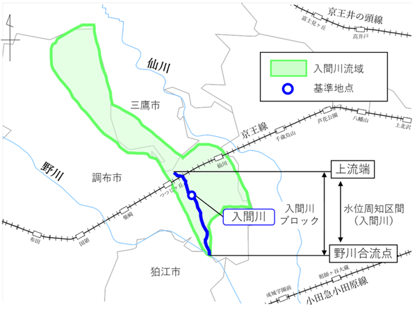
In Tokyo, 12 rivers have been designated as such: Zenpukuji River, Yazawa River, Maruko River, Nomi River, Tsurumi River, Onda River, Shinkoji River, Sakai River, Shirako River, Yanase River, Karahori River, and Narabashi River.
*2: What is flood risk information?
This disaster prevention information is issued when there is a risk of rivers overflowing due to heavy rain, and is equivalent to Alert Level 4, which requires evacuation from dangerous areas. It is issued when the river water level reaches the special flood alert water level set in advance at the reference point.
1 Planned start date of operation
Friday, April 11, 2025
*Operation will begin as per the provisions of the Tokyo Flood Prevention Plan (scheduled for April 11, 2025).
2 Providing information to Tokyo residents
Your local ward, city, town, or village will communicate the information via disaster prevention radio and email services, and with the cooperation of media organizations, will disseminate information on television and radio. You can also check the latest announcements of flood risk information on the Tokyo Metropolitan Government’s website and Tokyo Metropolitan Disaster Prevention X (formerly Twitter).
Tokyo Metropolitan Flood Disaster Prevention Information System


3 When flood risk information is announced
Water level notification: In rivers where water levels rise extremely quickly during heavy rainfall, there is a risk of the river overflowing in a short period of time after a flood danger information is issued.
When flood danger information is announced, people in risky areas along rivers are asked to take early action, such as moving from basements or other places at high risk of flooding, and evacuating to higher ground, such as the upper floors of buildings.
(Reference) Location map of Irimagawa River
This project is an initiative to promote the “Tokyo 2050 Strategy.”
Strategy 21: Strengthening urban resilience ”Strengthening measures against increasingly frequent and severe storm and flood disasters”
| Contact Disaster Prevention Division, River Department, Bureau of Construction Phone: 03-5320-5190 Email: S0000386(at)section.metro.tokyo.jp |
その他のお知らせ
-
 Earthquake
 -
 Earthquake
 -
 Wind and flood damage
 -
 Earthquake